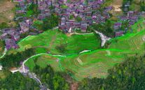
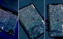
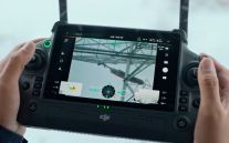
Penetrate Tree Canopy and Vegetation with High-Accuracy Aerial Surveying

SITECH Solutions offers a LiDAR drone solution that delivers precise topographic data, even in challenging environments with dense vegetation or uneven terrain.

Powered by the DJI Matrice 350 RTK and Zenmuse L2 LiDAR sensor, this system is ideal for construction, mining, environmental studies, and large-area surveys where ground surface detail is critical.

LiDAR drones night vision Matrice 350 RTK

What is LiDAR Technology?

Reliable Data in Complex Terrain

Unlike photogrammetry, LiDAR technology uses laser pulses to penetrate vegetation, delivering an accurate representation of the true ground surface.

Mounted to the rugged DJI Matrice 350 RTK, the Zenmuse L2 sensor captures high-density point clouds and georeferenced data with exceptional accuracy and efficiency.

Lidar Drones SITECH Solutions Precise Ground Surface Modelling

Integrated LiDAR Drone and Sensor System

DJI Matrice 350 RTK

The DJI Matrice 350 RTK is an advanced enterprise drone engineered for professional aerial operations, combining powerful performance with high reliability. It offers up to 55 minutes of flight time, supports multiple payload configurations - including Zenmuse L1 and P1 sensors - and features six-directional sensing and positioning for enhanced safety. With an IP55 rating and DJI O3 Enterprise Transmission delivering triple-channel 1080p HD video up to 20 km, it excels in surveying, inspections, and public safety applications.

LiDAR drones DJI Matrice 350 RTK
DJI Zenmuse L2

The DJI Zenmuse L2 is a high-precision aerial LiDAR and photogrammetry payload designed for seamless integration with DJI's Matrice 300 RTK and Matrice 350 RTK platforms. It combines a frame-based LiDAR module, a self-developed high-accuracy IMU system, and a 20MP 4/3 CMOS RGB mapping camera to deliver detailed and reliable geospatial data. With a detection range of up to 450 metres and support for up to five returns, the L2 excels in penetrating dense vegetation and capturing intricate details. When paired with DJI Terra software, it offers a comprehensive solution for efficient 3D data collection and high-accuracy post-processing.

LiDar drones DJI Zenmuse L2 LiDAR

Key Features of SITECHs’ LiDAR Drone Solution

  • Precise Ground Surface Modelling

    Collect clean, accurate ground data beneath trees, grass and structures using the Zenmuse L2’s integrated LiDAR and RGB mapping camera. Ideal for applications where terrain data accuracy is essential.

  • All-in-One Integrated LiDAR Sensor

    The Zenmuse L2 features a high-precision IMU, frame LiDAR, and a 4/3 CMOS RGB mapping camera—all in a single compact payload.

  • Powerful Drone Platform

    The DJI Matrice 350 RTK delivers up to 55 minutes of flight time, a 2.7kg max payload, and IP55 weather protection, ensuring performance in tough environments.

  • Advanced Positioning and Safety

    Equipped with 6-directional obstacle sensing, RTK positioning, night vision FPV camera, and arm-lock detection for added safety and control.

  • Efficient Data Workflow

    Collect, process, and analyse data quickly with DJI Terra or integrate with your preferred GIS or CAD software. The system supports repeatable mission flights and automated post-processing workflows.

LiDAR Drone Applications

Earthworks and Civil Construction

Improve project planning and monitoring with fast, accurate elevation models and cut/fill analysis.

Mining and Quarrying

Perform volume calculations, pit mapping, and terrain modelling with precise ground-level data.

Environmental and Forestry Surveys

Penetrate dense canopy cover to study ecosystems, monitor deforestation, or assess terrain conditions for conservation.

Flood Modelling and Drainage Planning

Generate accurate terrain models that support hydrological analysis and stormwater infrastructure design.

Lidar drones Matrice 350 RTK data sharing across platforms

Why Choose LiDar Over 
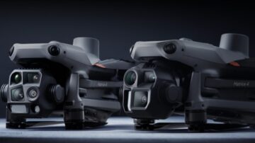
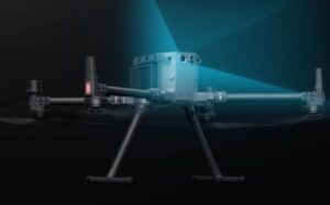
Photogrammetry Drones?

While photogrammetry offers high-resolution visuals, LiDAR stands out when accurate terrain data is required beneath vegetation or in areas with limited surface visibility. It’s a must-have for projects that demand precision beyond the visible surface.

Lidar drones Matrice 350 RTK commercial drone solution

Why Choose SITECH Solutions’ LiDar Drones?

As an authorised Trimble dealer and DJI Enterprise  partner, SITECH Solutions provides end-to-end drone solutions with full support. From payload selection and drone configuration to post-processing software integration, we help you make the most of your aerial data.

Request a Quote or Demo

Get in touch to learn more about the DJI Matrice 350 with Zenmuse L2 and how LiDAR drone mapping can transform your data collection process.

Related Applications

From aerial data processing to LiDAR-enabled capture, these solutions work alongside photogrammetry drones to improve efficiency and accuracy on every site.